

Collection: Osher Map Library Collection
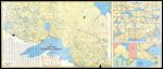
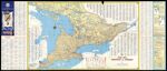
Name: Ontario, Official Road Map: issued 1953
Barcode:
Image Number:
Creator:
Publishing Location:
Notes: Panel title. Revised annually, 1953. Includes indexes, traffic information, mileage tables, color panel illustrations, and 29 ancillary maps.
Date/Date Range Produced:
Date/Date Range Published:
Language:
Dimensions: on sheet 49 x 115 cm folded to 25 x 9 cm
Physical Description: 2 maps on 1 sheet: both sides, color
LC Call Number: G3461.P2 1953 .O5
OCLC: 298112707
Accession Number: OML-1953-55
Donor:
Permanent URL: